
2020.8.27
Accurate Dating of Paleotsunamis in Eastern Hokkaido Through High-Precision Sediment Analysis

Assist. Professor Takashi Ishizawa
Disaster Science Division
▷Introduction
The Japanese archipelago has been hit by subduction-zone earthquakes and the tsunamis caused by them many times; these earthquakes and tsunamis had a certain degree of periodicity. The actual mechanism of a subduction-zone earthquake is complex, and thus the interval between earthquakes and tsunamis is calculated only as a rough estimation. However, it is extremely important to learn from the past in order to know the current earthquake and tsunami risks and prepare for the future, based on the major premise that natural hazards occur repeatedly.
Assistant Professor Takashi Ishizawa of IRIDeS has conducted research to measure the age of paleotsunamis as accurately as possible with choronological methods, focusing especially on strata. One of his research topics is the traces of tsunami that occurred along the Kuril Trench.
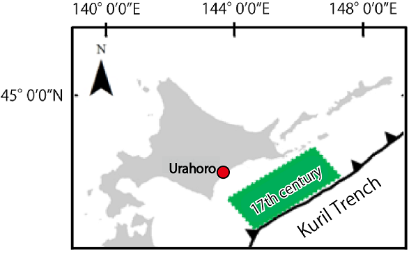
The reality of the earthquakes and tsunamis that occurred along the Kuril Trench in the past had long been a mystery, as there were no historical documents on these disasters. However, several geological surveys have been conducted since the beginning of the 21st century, proving that tsunamis have occurred many times in the past along the Kuril Trench. They also revealed that the most recent major tsunami that left traces in eastern Hokkaido was caused by an earthquake with an estimated Mw of 8.8, and that it arrived in the 15th to 17th centuries.
Geology has made great strides in unraveling the reality of tsunamis, but the ages of past tsunamis in the existing studies tended to be only rough estimates. Thus, Ishizawa and his research team members took on the challenge to narrow down the estimated time spans through a highprecision sediment analysis.
▷Obtaining a Cross Section of the Stratum through a Field Survey
The team first conducted a trench survey in Urahoro Town, Hokkaido [Fig. 1], which was one of the affected areas of the paleotsunami. They dug a wetland 400 m inland from the coast, approximately 2 m from the ground surface, and took out sliced strata as thin plate soil. As a result, a crosssectional view of the soil with a height of 2 m appeared, with alternate layers of peat and sand. The team confirmed a total of eight sand layers within the strata. “Basically, mud accumulates thickly in wetlands. The presence of multiple sand layers in the strata suggests that the sand was transported by water flows with high energy such as tsunamis,” says Ishizawa. For further analyses, the team carefully encased the excavated stratum plate, refrigerated them to prevent mold, and carried them to the laboratory.
▷Examining 70 Samples from the Peat Beds of the Obtained Strata
Next, the team collected peat just above and below the sand layers that were assumed to be tsunami deposits to examine their formation ages by carbon-14 dating. “What we want to know is the formation age of tsunami deposits, but the measurement is not of the sand layer, but the peat layer. This is because the sand was transported from another place with mixing and was redeposited there. Since the old and the new should be mixed together in the sand layer, it is not considered to be optimal for dating,” says Ishizawa. Therefore, they explored the age of the tsunami deposits by examining the age of the adjacent peat.
The conventional research method to illuminate the age was to examine only one point above and one point below the tsunami deposit layer. However, the method of Ishizawa’s research team is different. They minutely dated the strata, examining a total of 70 points taken from the oldest to the latest layer in 5 to 7 mm intervals. Before introducing the advantages of their method, this article will explain carbon-14 dating.
▷What is Carbon-14 Dating?
Organisms on Earth contain a certain amount of carbon 14 (14C), which is a radioactive element. When an organism dies, 14C keeps decaying at a constant rate. Thus, it is possible to estimate when a substance containing 14C was produced by measuring the amount of remaining 14C. Peat layers are made by undecomposed and piled-up plants such as dead leaves. By examining the remaining 14C of plants that were trapped in a peat layer, it is possible to estimate the age when the layer was formed.
The specific steps of carbon -14 dating are as follows: Burn the collected soil into a gas and separate CO2 from it. Reduce or remove O2 to provide the individual C, graphite. Then, place a mass of C weighing approximately 1 mg in an accelerator mass spectrometry (AMS). “At this stage, three types of C are mixed together, that is, 12C, 13C, and 14C. When accelerated by an AMS, the orbit changes depending on the mass, and thus the heaviest 14C can be separated and extracted,” explains Ishizawa. The research team set approximately 20 samples at a time, and rotated the accelerator for about three days for each time. Afterward, they counted the number of 14C extracted. “The amount of remaining 14C tends to be about 1,000 to 10,000, though it depends on the strata age,” says Ishizawa.
Here, however, a problem occurs. The rate of decrease in 14C is constant, but the concentration of 14C in the Earth’s atmosphere varies from time to time because of events such as past solar activities. In some cases, it is not possible to tell whether the same amount of 14C is from the time when 14C was at a high level or from a more recent period. A calibration curve is used to convert radiocarbon ages into calendar years, but in some cases, for the formation of one stratum, more than one candidate age is presented. For example, we know that terms such as “around 1450” and “around 1600” are confusing when current 14C residues are similar to each other.
The similarity of the residual 14C amount between 1450 and 1600 was one of the reasons why the most recent tsunami that hit eastern Hokkaido had been estimated to be roughly in the 15th to 17th centuries. This has also affected estimations of other paleotsunamis. For example, by employing the conventional carbon-14 dating method, it was difficult to distinguish whether the tsunami deposits collected at a certain location were derived by the 1454 Kyotoku Tsunami or the 1611 Keicho Tsunami. This caused many academic controversies.
▷Using High-Precision Measurement to Narrow Down a Tsunami’s Age
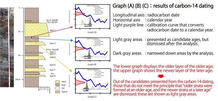
However, the study of Ishizawa’s team exceeded the conventional limits. They measured all of the 70 samples taken from the strata and compared them with each other, which is the unique characteristic of their method. By analyzing only one point, it is not possible to tell which age range is correct when more than one range is proposed according to the residual amount of 14C. However, if there are many results from several points, and if they are arranged from the oldest to the newest stratum, and if they are considered with the reason that “older strata was formed at an older age, and the newer strata at a later age,” then candidates that do not conform to this principle can be rejected. Thus, the estimated age can be narrowed down.
For example, let us look at Figure 2, Graph (C), where the carbon -14 dating analysis provided four candidates: “1500 -1600,” “1600 -1700,” “1700 -1800,” and “1900 and beyond.” Examining only this graph cannot tell us which candidate is more valid. However, if you align it with Graphs (A) and (B), which show the results of newer strata analysis, the stratum in Graph (C) must naturally be older than those in Graphs (A) and (B). Therefore, we can conclude that out of the original four candidates from Graph (C), “1500 -1600” is correct, and that the rest are incorrect.
Through this study, Dr. Ishizawa and his colleagues successfully narrowed down the ages of all the eight sand layers to about 60% of those estimated in previous studies. Earlier, it was roughly considered that the paleotsunami occurred between 1424 and 1667, based on the analysis of limited samples. However, this study more accurately showed that the tsunami occurred between 1600 and 1667.1)
▷About the Future
Dr. Ishizawa believes that the method used in this study can resolve many “1454 Kyotoku Tsunami or 1611 Keicho Tsunami” disputes. He assumes that the same approach can solve the questions of tsunami deposit ages in the Sendai Plain. Geological surveys and carbon-14 dating are both time-consuming and expensive, but they are also very effective.
As a boy, Ishizawa was attracted to fossils and minerals. The Great East Japan Earthquake occurred when he was a university student, and he decided to study tsunami deposits. As he says, “In this study, we confirmed the age of past tsunamis on the east coast of Hokkaido more accurately. It is considered that no major tsunami has occurred in this area afterwards. It means that with the periodicity of tsunamis, the next major earthquake and tsunami could occur in this area at any time.” Dr. Ishizawa would like to continue to illuminate tsunamis and other disasters towards disaster risk reduction in the future.