
2021.12.10
【Activities】Reconstruction of the 1611 Keicho Oshu Earthquake and Tsunami Around the Tagajo Area

Associate Professor
Daisuke Sugawara
Tsunami Engineering Lab
In 1611, a major earthquake and tsunami struck the Pacific coast of Tohoku region. Until recent years, the size of the 1611 earthquake and tsunami was considered similar to that of the 1933 Sanriku Earthquake and Tsunami—a disaster that caused severe damages mainly along the Sanriku Coast of Iwate and Miyagi Prefectures. Thus, the 1611 disaster was named “Keicho Sanriku Earthquake and Tsunami.” However, the progress of research, especially after the 2011 Great East Japan Earthquake, revealed that the size of the 1611 earthquake and tsunami was much larger than previously estimated, and its damage extended throughout Oshu, which is the name of ancient province that comprised the Pacific side of Tohoku region. Thus, scientists call it “Keicho Oshu Earthquake and Tsunami” today.
On December 4, 2021, a symposium titled “New developments in disaster science guided by history V: Research on the 1611 Keicho Oshu Earthquake and Tsunami integrating arts and science” was held at IRIDeS in a hybrid style that combined face-to-face and online methods. In the symposium where over 200 people participated, 10 researchers from various fields of the humanities and sciences made a presentation on their latest views and findings regarding the 1611 disaster. Associate Professor Daisuke Sugawara of the Tsunami Engineering Lab, IRIDeS, gave a talk regarding numerical modeling of inundations and topographic changes caused by the 1611 Keicho Oshu Earthquake and Tsunami in the area around the ancient Tagajo castle1), which was achieved by collaborations with experts on cultural heritages, engineering, and earth science.
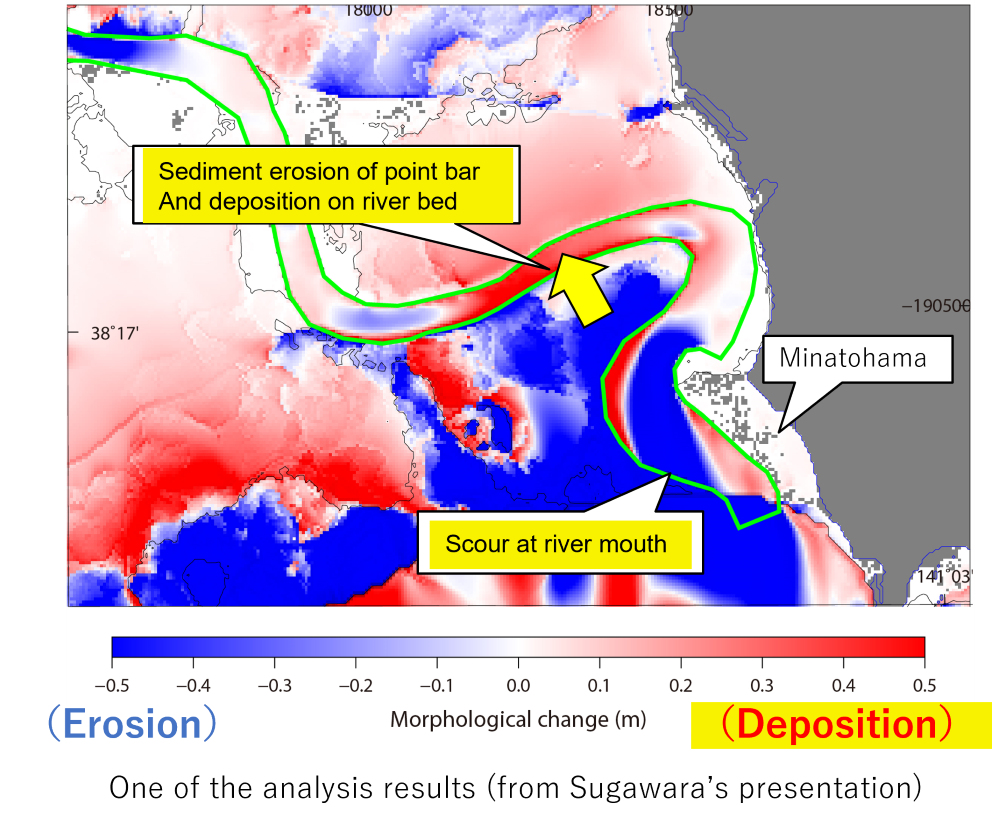
The outline of Dr. Sugawara’s talk was as follows. First, he developed a digital elevation model (DEM) of the past Tagajo area using aerial photographs taken in 1961, at which time anthropogenic modifications of the coast and land had not yet been made. Second, he corrected the DEM, considering present topography, elevations of the paleo-surface of archaeological sites, and findings from historical documents, in order to reconstruct in the most possible detail the paleo-topography of the Tagajo area in the Keicho period. Finally, he analyzed how the 1611 tsunami changed the topography through a numerical modeling of tsunami sediment transport. The results showed that simulated topographic changes and sand deposition well coincide with descriptions in the historical documents and findings from the archaeological surveys.
Sugawara says, “We were able to provide physical explanations that support historians’ findings by using the approach of coastal engineering. However, various issues still remain, such as assessment of uncertainty in the reconstructed topography; further research is necessary. We would like to illustrate a clearer view of the 1611 great tsunami. Field surveys and new evidences will be a key for that.”
1) Tagajo is an archaeological castle site, located in Tagajo City, Miyagi Prefecture.